Trail On foot La Grave - Le Chazelet - Refuge du Pic du Mas de la Grave en boucle - Photo

Le Chazelet - Refuge du Pic du Mas de la Grave en boucle

 Pierre Lefèvre
Pierre Lefèvre

User GUIDE

© OpenStreetMap contributors
Length
Length
9.9 km
Max alt
Max alt
1995 m
Uphill gradient
Uphill gradient
349 m
Km-Effort
Km-Effort  
14.5 km
Min alt
Min alt
1737 m
Downhill gradient
Downhill gradient
351 m
Boucle
Boucle
Yes
Creation date :
2023-03-08 08:59:18.218
Updated on :
2023-03-08 09:38:10.821

(0 Reviews)

On foot
On foot
2h55
Difficulty : Easy
Snowshoes
Snowshoes
3h30
Difficulty : Easy

Scan this QR Code to open this trail in the SityTrail application

FREE GPS app for hiking

Logo SityTrail SityTrail

IGN / Geographical institutes

Download SityTrail from the App Store Download SityTrail from Google Play

Logo SityTrail SityTrail World

The world is yours!

Download SityTrail from the App Store Download SityTrail from Google Play Download SityTrail on Huawei AppGallery

About

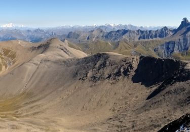
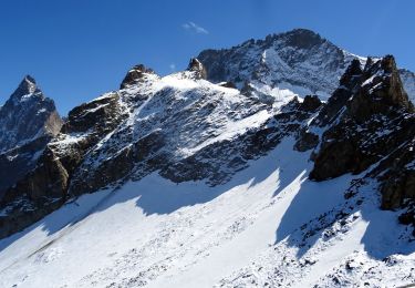
Trail On foot of 9.9 km to be discovered at Provence-Alpes-Côte d'Azur, Hautes-Alpes, La Grave. This trail is proposed by Pierre Lefèvre.

Description

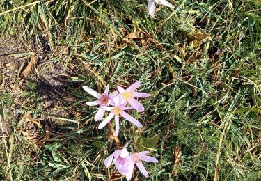
Cette randonnée est idéale pour découvrir la région de la Grave en douceur.

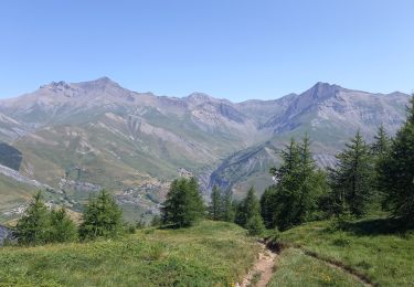
Le tracé ne présente aucune difficulté particulière. A l'aller vous aurez le Pic du Mas de la Grave (3020 m) face à vous, et au retour la majestueuse Meije (3983 m).

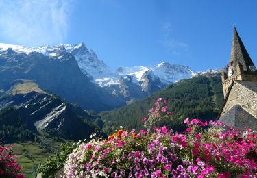
Au départ du Chazelet (nombreuses places de parking) rejoignez le torrent du Gâ avant de monter jusqu'au Clos Raffin.

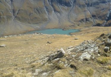
L'itinéraire s'élève progressivement jusqu'au torrent des Combettes qu'il vous faudra suivre avant de traverser le Gâ pour rejoindre le Refuge du Pic du Mas de la Grave (1944 m).

Profitez d'un bon repas accompagné d'une bière locale, d'un verre de cidre ou d'un sirop (je vous recommande chaudement de craquer pour un petit sucré au dessert ou au goûter !).

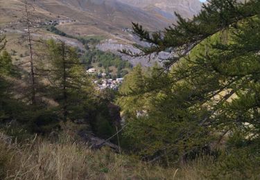
Le retour se fait le long du Gâ en ligne droite jusqu'au Chazelet en traversant le hameau d'estive du Rivet.

Elevation profile

Photos

Positioning

Country:
France
Region :
Provence-Alpes-Côte d'Azur
Department/Province :
Hautes-Alpes
Municipality :
La Grave
Location:
Unknown
Start:(UTM)
286124 ; 4992668 (32T) N.

Trails nearby

Trail Walking Villar-d'Arêne - L'Aiguillon et Lac du Pontet 28.8.22  - Photo
Walking
GUIDE
fredetpascale

Walking

Very easy
(1)
Villar-d'Arêne, Provence-Alpes-Côte d'Azur, Hautes-Alpes, France
6 km | 9.4 km-effort
2h 0min
Yes
Trail Walking La Grave - L'aiguille du Goléon - Photo
Walking
tracegps

Walking

Very difficult
(1)
La Grave, Provence-Alpes-Côte d'Azur, Hautes-Alpes, France
9.1 km | 25 km-effort
5h 0min
No
Trail Walking La Grave - 05 lac goleon - Photo
Walking
GUIDE
randodyssée

Walking

Medium
La Grave, Provence-Alpes-Côte d'Azur, Hautes-Alpes, France
14.4 km | 28 km-effort
6h 2min
Yes
Trail Walking La Grave - 05 refuge e chancel - Photo
Walking
GUIDE
randodyssée

Walking

Medium
La Grave, Provence-Alpes-Côte d'Azur, Hautes-Alpes, France
11.4 km | 25 km-effort
7h 19min
No
Trail Walking La Grave - vallons de la Meije : lac Puy Vachère - Photo
Walking
GUIDE
nadinebondoux

Walking

Very difficult
La Grave, Provence-Alpes-Côte d'Azur, Hautes-Alpes, France
12.7 km | 27 km-effort
5h 44min
Yes
Trail Walking Villar-d'Arêne - SityTrail - Lac du pontet et l'Aiguillon - Photo
Walking

Walking

Medium
(1)
Villar-d'Arêne, Provence-Alpes-Côte d'Azur, Hautes-Alpes, France
5.2 km | 8.6 km-effort
1h 56min
Yes
Trail Walking La Grave - 2020-09-03 Marche Tour de la Grave au plateau d'Emparis par le Pic du Mas de la Grave (3 jours) - Photo
Walking
GUIDE
holtzv

Walking

Medium
La Grave, Provence-Alpes-Côte d'Azur, Hautes-Alpes, France
51 km | 88 km-effort
17h 56min
No
Trail Walking La Grave - 2020-09-03 Marche La Grave au Refuge du Pic du Mas de la Grave - Photo
Walking
GUIDE
holtzv

Walking

Very easy
La Grave, Provence-Alpes-Côte d'Azur, Hautes-Alpes, France
12.2 km | 23 km-effort
4h 58min
No
Trail Walking La Grave - 2020-09-06 Marche La Grave Gare de Peyrou d'Amont au Col des Ruillans - Photo
Walking
GUIDE
holtzv

Walking

Medium
La Grave, Provence-Alpes-Côte d'Azur, Hautes-Alpes, France
6.2 km | 15.7 km-effort
3h 30min
No


Close
My subscriptions